Disclaimer
While the GIS Office strives to maintain accurate data, the City of Richmond does not guarantee its maps or data to be complete, accurate, current, or without error, nor does the City guarantee the fitness of the data for a particular use.

Geographic Information Systems and Mapping
911 Addressing
With the emergence of automated computer-controlled emergency services (9-1-1 systems) it is important that proper addressing be emphasized. A central and crucial component of 911 is a comprehensive, accurate, and sequential addressing system. A properly standardized, maintained, accurate, and consistent address data system is an essential reference tool that is vital to the operations of Fire, Police, and other service entities in the protection and preservation of lives and property. With this in mind, The City of Richmond strives to make sure our addressing system is as accurate and up to date as possible.
Any questions concerning addressing should be directed to this department. Also, please feel free to navigate our interactive map to find any address within the city.
What is GIS?
From the USGS Website:
“A Geographic Information System (GIS) is a computer system that analyzes and displays geographically referenced information. It uses data that is attached to a unique location. Most of the information we have about our world contains a location reference: Where are USGS stream gages located? Where was a rock sample collected? Exactly where are all of a city’s fire hydrants?
“If, for example, a rare plant is observed in three different places, GIS analysis might show that the plants are all on north-facing slopes that are above an elevation of 1,000 feet and that get more than ten inches of rain per year. GIS maps can then display all locations in the area that have similar conditions, so researchers know where to look for more of the rare plants.
“By knowing the geographic location of farms using a specific fertilizer, GIS analysis of farm locations, stream locations, elevations, and rainfall will show which streams are likely to carry that fertilizer downstream. These are just a few examples of the many uses of GIS in earth sciences, biology, resource management, and many other fields.”
What does this mean for the City of Richmond?
How does Richmond use GIS?
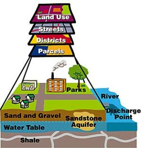
Visual of the various GIS layers
Included in our GIS are 911 addresses, streets, impervious surfaces (sidewalks, buildings, driveways, basically any area that covers ground surface and prohibits rain to absorb into the ground naturally), storm water features (catch basins, storm pipes, detention/retention ponds), zoning/landuse, etc. we collect and maintain this data on a constant basis in order to have the most current and accurate tool to help us serve and assist city government and the community.
Interactive & Printable Maps
To check to see if you are in a floodplain, enter you address at the link below:
https://msc.fema.gov/
The City of Richmond’s interactive maps are searchable by address. There are tools on the right-hand side of each map to help you navigate each map and interpret the information shown.